All the roads lead to Roma!
Across the countryside, the Via Romana connected La Gaulle to Roma through Lyon city by the South of France. The Place of Italia became the new name in the actual Paris of the crossroad of the Roman conquerors.
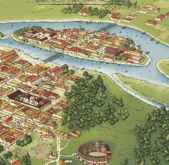
The Roman people liked building cities in order. When the surveyors drawed a plan, they made a grid one of straight lines as for a military camp. The main street was the Cardo Maximus crossing the city from the North to the South. Everything that came and left Lutecia went through this way. It was on this North-South axis that the less important streets were aligned, the Cardo or the Decamunus streets for the parallel or perpendicular lines.
The actual street of St Jacques in Paris is the authentic Cardo Maximus of Paris-Lutecia. She extended towards the North, Rive Droite by the St Martin street and towards the South joining the Orleans road.
The Gauls Parisii people lived on the islands of the Seine river and the Romans on the Rive Gauche toward the South. In this second century, Paris – Lutecia became a permanent economic and cultural exchange, an era of peace during 300 years where the new sedentary constructions were built. They used to meet in places of relaxation as the Thermes of Cluny, the quintessence of luxury and comfort open to everyone for free, important meeting and hygienic points and also in Arena of Lutecia, spectacular amphitheatre for 17 000 spectators where games of gladiators, comedies and tragedies were popular with the public.
Gauls Parisii and Romans were very united to build Paris – Lutecia from 52 B.C.